|
|
|||
|
I got a ticket! Well, that part isn't unusual. I had a ticket for 2006 and 2007 as well. Unfortunately, I wasn't able to go either of those years due to work commitments. This year I was determined to go "no matter what". The following is a summarized version of the week and a half of riding which has turned out to be my longest motorcycle ride to date. For one who has never taken a two week vacation, you can't ride very far, but I do the best I can with what I've got. Thursday, August 28, 2008 I arrived at the hotel with ease. The three flags outside the hotel was a good landmark. As I arrived, I discovered a parking lot full of motorcycles. "This must be the place" I said to myself. I parked my bike and proceeded to check in to the hotel. I had arrived too late to check in for the event so I had to do that in the morning. "Registration opens at 2:30 am" the sign said. As it turns out, my roommate, Terry Packer, had already checked in. The desk clerk gave me a key and I proceeded to the room. Soon after introductions, I took a quick shower and it was time for bed. Total for the day: 186 miles |
|||
|
|
|||
|
Route for Thursday, August 28, 2008 |
|||
|
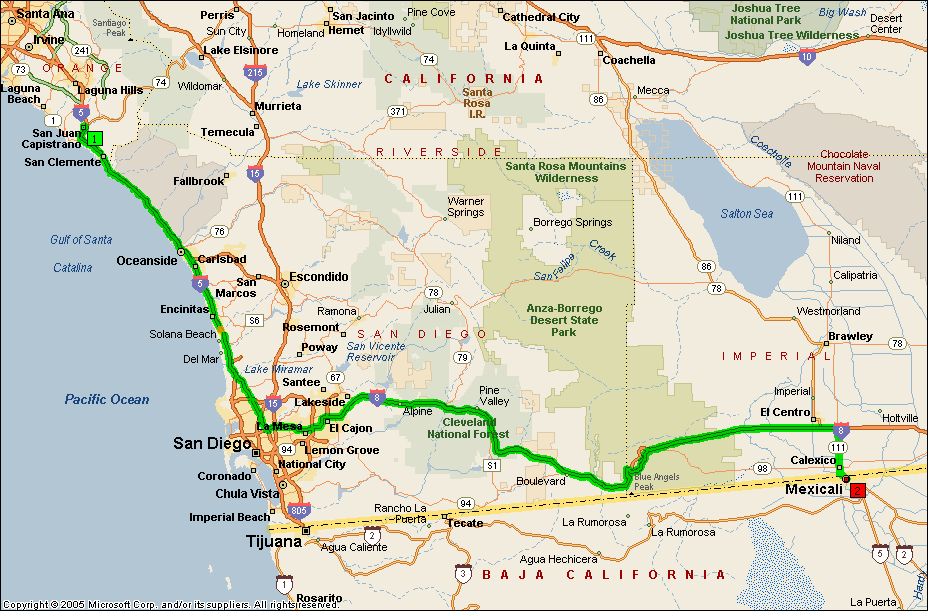
Friday, August 29, 2008 It was about a half hour wait at the border crossing, but we were soon on our way. The air temperatures were already warm. The overnight low was supposed to be 84oF and I think that was pretty accurate. Our route took us on the western edge of the Salton Sea to I-10. The official route had us cutting off at Hwy 62 to Hwy 247, but I had ridden that road so much, I wanted to save some time as well as get gas and breakfast at a known location in Banning. After breakfast, I continued on I-10 to I-215 through the Cajon Pass. I continued to see motorcycles all the way up Hwy 395. The parking lot and gas pumps were full at Pearsonville where I made my next gas stop and snack break. This year I am also participating in the SCMA California National Parks Adventure (click here to see how I am doing) where I am to visit all 24 of the National Parks, Monuments and Historic Sites which are in California before December 15th. I decided to use the Three Flags Classic as an opportunity to get as many of these sites as I could. There happened to be one on the way which is Devil's Postpile outside of Mammoth, CA. I make my stop, catch the shuttle and visit the site for the first time in my life. The excursion takes about three hours, but is worth it. Once back on the road, I have my nose pointing towards the checkpoint in Gardnerville, NV. I arrive late in the afternoon and it is apparent that many riders have checked in before I had. I'm not surprised due to my "detour" at Devil's Postpile. What does surprise me is that there are several who have not checked in yet. One of those is my roommate Terry who soon rolls in. Terry reported that he too didn't get much sleep (something about snoring in the room which didn't make any sense to me since I didn't hear any snoring) and had to stop a couple of times for an IBA power naps. After refreshments and conversation, I am off to my campsite in Emerald Bay, on the edge of Lake Tahoe. Total for the day: 652 miles and I achieve 200,000 miles on BMWs. |
|||
|
click on image for larger version |
|||
 |
 |
 |
|
|
Devil's Postpile |
A shot of the park sign |
A better shot of the park sign |
|
 |
 |
 |
|
|
The first checkpoint in Gardnerville, NV. I arrived late, so most of the crowd had already checked in. |
My campsite at Emerald Bay (Lake Tahoe). | ||
|
|
|||
|
Route for Friday, August 29, 2008 |
|||
|
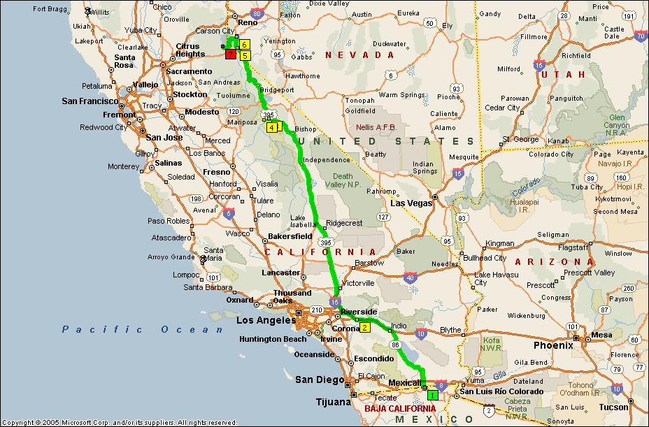
Saturday, August 30, 2008 I'm checking my time and I am certain that I am going to be late getting to the visitor's center in Whiskeytown. As I proceeded west and cross I-5, I encounter six motorcyclists. The two lead riders are wearing Hell's Angel's colors (Alaska chapter). They are on a mission and have no time to acknowledge this "citizen" which is fine by me. It's after 5 pm as I reach the visitor's center and, while I'm certain it is closed, I decide to stop anyway. It's a good thing I do stop because this particular visitor's center is open until 6 pm. Glory be! I made it! Whoopie! Next up is this glorious road called Hwy 299. I love this road. It has nice sweepers which aren't too much work but tight enough to be interesting. The pavement is good. The traffic is light. Ahhhh.... As it turns out, the original route (Hwy 36) was closed due to an accident by an 18 wheeler, so the rest of the entrants also had the opportunity to enjoy Hwy 299. Hwy 36 is a great road, but it is much tighter and twistier. It's more work than Hwy 299. My problem was that it's still a long ways to my campsite in Prairie Creek which is part of the Redwoods National Forest. I arrive by 10:00 pm. My neighbor feels sorry for me and brings me a great lantern to help me pitch my tent. I am most appreciative. Total for the day: 682 miles |
|||
 |
 |
 |
|
| The park sign at Lava Beds National Monument. This park requires a lot of time to explore. Maybe I'll do that at a later date. | The park sign at Lassen National Park. | ||
 |
 |
 |
|
| Mt. Lassen | The park sign at Whiskeytown. | My campsite at Prairie Creek Redwood State Park. | |
|
|
|||
|
Route for Saturday, August 30, 2008 |
|||
|
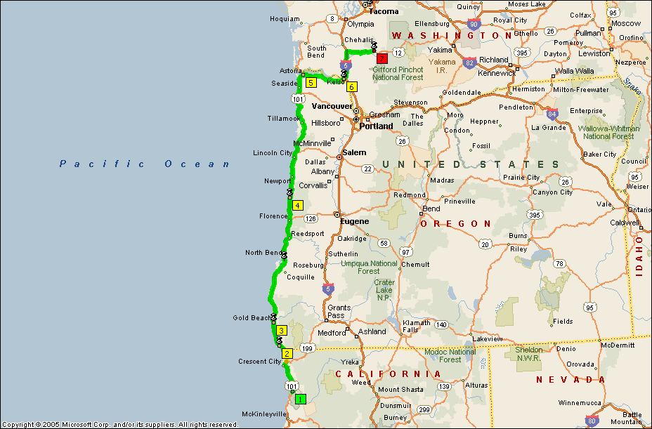
Sunday, August 31st, 2008 Not much farther up the coast I encounter the two Canucks again, Gordy and Richard. Gordy is from Whitehorse who will eventually will the "Long Distance Male" award at the ceremonies on Tuesday night. Richard is from the terminal city of Nanaimo, BC. Gordy is riding a Honda Blackbird and is having intermittent fuel delivery problems. After chatting with him in Brookings, I know he is more mechanically qualified than I am (he is a professional helicopter mechanic), but I can't pass a disabled comrade on the road. I make a U-turn and stop to see if I can help. I cannot as I suspected but I gave him my cell number "just in case". They are concerned about finishing and are hoping to get as close as possible to the next checkpoint. It's a "slow-go" along the Oregon coast. I had heard that it was slow, but I had no idea it was this slow. The typical speed limit is 45 mph (where drivers drive at 28 mph) interrupted by seaside resorts with 30 mph speed limits (where the traffic is less than 20 mph). This gets more and more aggravating as the sun starts to set. I have already determined that I cannot camp in Astoria as I had planned due to the fact that the next checkpoint closes at 10 am and it is more than two hours from the campsite to the checkpoint. This was poor planning on my part. It is already dark by the time I reach Astoria and my goal is to look for a motel as close to the checkpoint as possible. Gordy and Richard pass me before I reach Astoria and I am following them into town. They decide to turn off and I check to make sure they are stopping for a place to spend the night instead of tending to the fuel delivery problem. Once I'm convinced that they are looking for a place to stay, I continue on my route. I do not see a suitable motel before I reach Morton, WA. Unfortunately, there are no vacancies at the checkpoint motel. I continue on the route through Morton where I spot a vacancy sign at Roy's Motel. There is one room left. I am fortunate because I doubt if there is another room available this side of Tacoma. No wireless Internet. No in-room coffee. It would have to do. Total for the day: 606 miles |
|||
 |
 |
 |
|
| The visitor's center at Redwoods National Park. | The second checkpoint at Brookings, OR. | Still running behind the main pack, the coffee was low (and old). | |
|
|
|||
|
Route for Sunday, August 31, 2008 |
|||
Monday,
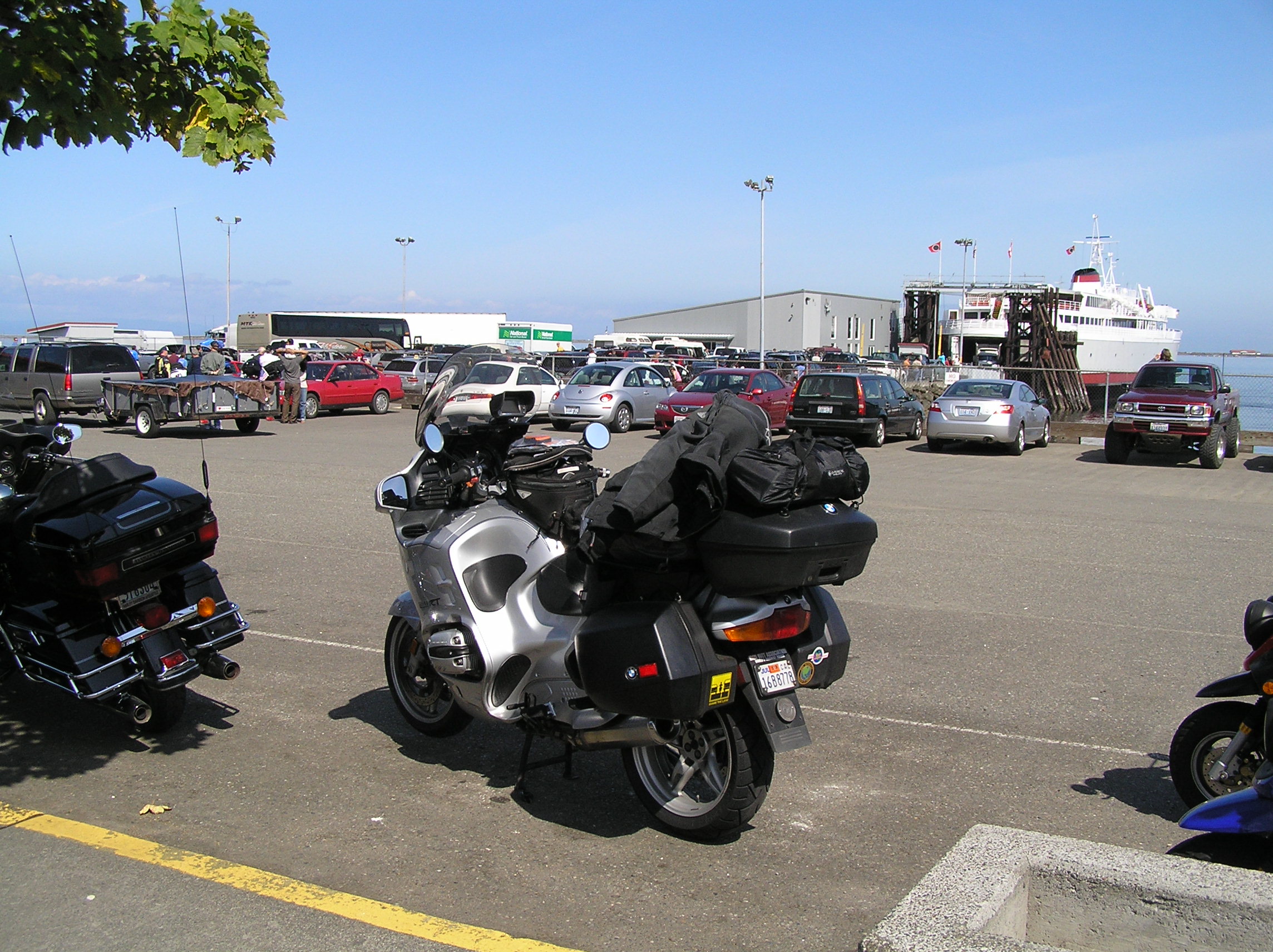
September 1, 2008 That period was also the first time I had ever camped. I recall a shipmate of mine and I had vowed not to spend another night on the ship once we docked. We had just spent a 9 month tour as members of the Tonkin Gulf Yacht Club and we were determined not to spend another night on the ship. As it turns out, none of the other 5,000 sailors wanted to spend another night on the ship either, so there were no apartments available closer than Tacoma. Disheartened, as we were driving back to the base, reconciled to spending another six months on the ship, we pass a K-Mart. We stop and pick up sleeping bags, a tent and cooking gear. We then proceeded to secure a campsite at a nearby campground. We stayed in that campsite for the month of August. Then the rain came. It rained and rained and rained some more. I don't think it stopped raining until we left in February. It didn't take too long for use to decide that sleeping on the ship wasn't that bad after all. I continue on to Port Angeles to catch my ferry to Victoria. I arrive an hour before the ferry is to depart and I find that I am on standby status with 7 other motorcycles who didn't already have a reservation. There were some anxious moments, but we were all able to board the ferry. We debark in Victoria and ride 70 miles or so to Nanaimo. I park my bike at the hotel and find that Terry has already checked in. There is a key waiting for me. Good man! I check in at the final checkpoint and receive my belt buckle. I find Huey Ward milling around who just collected his 14th belt buckle. We agree to meet for dinner and I go and unpack. The four of us, Terry, Huey, Mike Case and myself meet for dinner and relive the four day ride. Total for the day: 169 miles Tuesday,
September 2, 2008 |
|||
 |
 |
 |
|
| The lovely town of Morton, WA | The third checkpoint in Morton. I shouldn't have complained about the old coffee in Brookings. Here, there was no coffee or restrooms! | Waiting for the ferry at Port Angeles | |
 |
 |
 |
|
| The bikes getting ready to board the ferry in Victoria bound for Port Angeles. | Huey Ward (left), a South Coaster hanger-oner and Mike Case, actual South Coaster (and winner of the new Aerostitch suit) ready to board the ferry and head south. | Mike Case, tired of waiting. | |
|
|
|||
|
Route for Wednesday, September 3, 2008 |
|||
| Wednesday,
September 3, 2008 Today is the end of one adventure and the beginning of another. My wife, Nancy, is coming to Victoria by ferry after visiting her post-high school roommate in Seattle the past couple of days. Logistics are a challenge in that we decided that she would not pack motorcycle gear. I pick her up at the ferry terminal where there is conveniently waiting a tour bus which will take us to Butchart Gardens. I cover my bike and we are off to the gardens. We return about 3 pm where we get a bus ticket for her which will take her to Swartz Bay for the ferry to Vancouver which includes the ferry ride and a bus ride to the airport which is near our hotel. By the time I get back to my bike, pack the bike cover, put on riding gear, I realize that I will be cutting it close to make the ferry. I can't believe the Canadian speed limits, but I try to be as legal as possible. Amazingly, I arrive at the terminal 10 minutes before departure. I ride to the front of the line where there are four other motorcycles waiting and I don't have to wait more than a minute before riding onto the ferry. That was really close! As we disembark, I ride to the hotel to check us in and the hotel shuttle picks up Nancy at the airport. This worked pretty seamlessly. Total for the day: 108 miles Thursday, September 4, 2008 At the end of the day, we catch a bus back to our hotel. Total for the day: 0 miles |
|||
 |
 |
 |
|
| Nancy adding to the beauty of Butchart Gardens in Victoria. | |||
 |
 |
||
|
Nancy at Butchart Gardens. |
|||
 |
|||
| Nancy at Butchart Gardens. | Nancy at Chinatown in Vancouver, BC. | ||
|
Friday, September 5, 2008 By the time I get near Corvallis, OR, I am tired of the Interstate and cut over to Hwy 101. Yes, the Oregon Coast. It's not as bad this time since it is not a holiday weekend. I find it quite enjoyable. Unfortunately, I'm not making good enough time for me to reach my motel in Eureka and I don't want to chance screwing up the whole trip by pushing myself too hard. I decide to stop in Brookings, OR. Total for the day: 668 miles |
|||
 |
 |
 |
|
| The Oregon Coast. | |||
 |
 |
||
| An elk encounter in Northern California. | |||
 |
 |
||
 |
|||
| The requisite "bridge under construction" shot. | How would you like this for your office? | ||
|
|
|||
|
Route for Friday, September 5, 2008 |
|||
| Saturday,
September 6, 2008 I'm on the road pretty early and I stop for breakfast in Eureka. There, I realize that I probably won't be able to reach my last California National Park, Yosemite, on this trip before they close. Oh well, I guess I have a future day ride in the works. I continue south on Hwy 101 and pick up a park stamp at the John Muir National Historic Site. As I continue south, I once again tire of the Interstate and take Hwy 156 over to Hwy 1 at Monterey. It is a glorious ride on the coast and I am able to reach Morro Bay before it gets dark. I transition back to Hwy 101 and continue south. By the time I get to Camarillo, I'm getting pretty tired so I decide to take PCH through Malibu which is slower and requires more mental activity. I pick up I-405 in Santa Monica at a time when traffic is light. I pull into the driveway at 12:30 am. Now, that's a full day's ride! Total for the day: 959 miles (*yes, I thought about going down to Oceanside and back to get 1,000 but I've got plenty of those certificiates) |
|||
 |
|||
| Route for Saturday, September 6, 2008 | |||