 |
 |
 |
|
June 16th-18th, 2006
Friday
I know I was late the minute I awoke. It was light outside. I was trying to get on the road by sunrise because it was going to be a long, hot day. The forecast was for 100 degrees in Las Vegas and even hotter in Mesquite. I managed to close the garage door at 6:45. The ride started off great. Many times, I have to spend an hour (or more) just traversing Los Angeles. Not this time. Ortega Highway ends just about at my driveway. I go "over the hill" in the opposite direction of the Friday morning commute. I have the road to myself.
I drop into Lake Elsinore and it is already getting warm. I follow Highway 74 to Perris and go north a short bit on I-15 until I reach San Jacinto Parkway. I follow that road east until it connects to Highway 79 north to I-10 east to Highway 62 just before I reach Palm Springs. I stop for gas in Morongo Valley. It's only 8:45 and it's already over 80 degrees. I decide to take a pre-emptive measure against the heat ahead by soaking my sweatshirt and putting it on under my jacket, regulating the rate of evaporation with the zippers in my jacket. This, along with the constant hydration via the fluid in my Camelback (50% water, 50% Gatorade), I will be able to tolerate the heat for the remainder of the day.
I continue east on Highway 62 until I turn off towards Amboy in Twentynine Palms. At Amboy, there is evidence that I am now on Historic Route 66. This road has more significance to others than it has to me because I neither watched the TV show in the 60s nor did I migrate from Chicago. However, it's a pleasant alternative to the Interstate. For the next hour or so, I meet a lot of Hondapotamuses (aka Honda Gold Wings) going the other direction. I cross I-40 at Fenner and turn north on Highway 95 at Arrowhead Junction, near Needles, California. There's a prettybad accident ahead involving one car and two semi trailers. Clean up is in process by the time I arrive. Thankfully, there appears to be only property damage in this incident.
I stop for gas and lunch in Boulder City. I want to follow Highway 166 around Lake Mead but I don't see any signs as I ride through town. I ask for directions at the gas station and I am convinced I know where I'm going. That feeling continues until I reach the security stop near Hoover Dam. Still no sign for 166. I almost get to the dam crossing (which, by this time of day has more than one meaning) before I make a U-Turn and head back through Boulder City and into Henderson where I find an alternate route (Highway 564). I reach the turnoff which should be 166, but it mentions geographic locations rather than a road number. I take that turn and, as it turns out, is the correct road. I guess this is one of those instances where a GPS would have been helpful.
As soon as I make the turn, I reach a pay station. It's a three dollar entrance fee but that's good for five days. Just a couple of miles after the pay station, I reach a flagman who stops me as well as everyone behind me. She says I have to wait for the pilot vehicle to escort us through the construction zone (one lane). She says he will be here in twenty minutes. Twenty minutes! It's one o'clock in the afternoon half way between Las Vegas and Lake Mead and I'm forced to stand on the pavement in my black riding gear for twenty minutes! I suck on my Camelback.
The pilot car safely escorts us through the treacherous construction zone and I'm once again in clean air. Even though I'm now well behind my self-imposed schedule, the determination to find this road is worthwhile. I still feel this way as I encounter rough (read: teeth rattling) sections of the road.
I connect with I-15 at Glendale, Nevada and take that route (the only option) to St. George, Utah where I get gas and hydrate. While there, I take photos of a project I worked on a few years ago which I haven't seen since the completion of construction. I also take the time to check in with Nancy (aka "The Boss") as well as return a call from a client to resolve a problem he encountered in advance of some field welding scheduled for the next day (Saturday).
After about an hour in St. George, I'm on my last leg of the ride. Although it's the last leg for the day, the adventure is not nearly over. Soon after leaving the city limits (5 pm California time), I turn east on Highway 9 through Hurricane and into Zion National Park where I pay another park fee. It's a spectacular ride through the park and well worth the ten dollars. I start planning a future trip for Nancy and I.
|
|
|
|
After exiting the park, I turn north on Highway 89 at Mt. Carmel. Highway 89 follows the Virgin River and is incredibly scenic. I start to cool off and, in fact, I'm a little chilled. It's amazing to actually turn on the heated grips when the air temperature is 74 degrees but, since I've spent most of the day over 100, I guess feeling cold at 74 is to be expected.
I roll into Panguitch a little after 7 pm (California time) and start looking for the rally site. I eventually find it, but I arrive after registration has closed. There is a stiff wind as I pitch my tent but it goes up without much difficulty. I take a brief tour of Rally headquarters before checking in with The Boss one last time. I then find a Subway restaurant across the street. After dinner, I find the showers. I organize my accommodations and I am "out" by 10.
 |
| Total Miles for the day | 635 | 85% |
| Interstate Miles | 97 | 15% |
Saturday
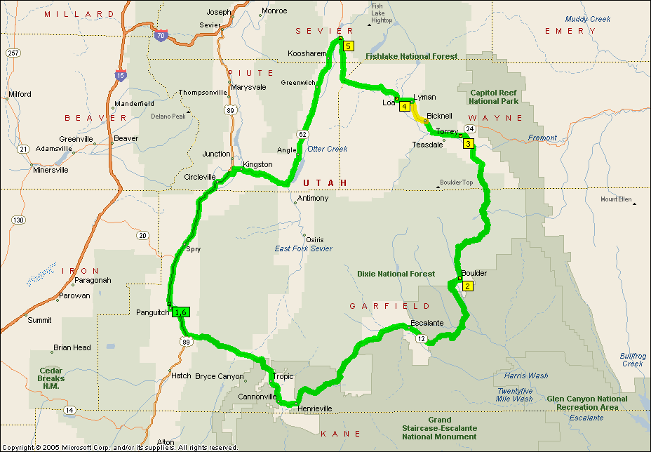
Today I go "green dot collecting". The green dots
are along scenic roads on AAA maps. I leave the camp going south on Highway 89
and turn left on Hwy 12 (green dots). I save
 |
 |
There’s plenty of time before the evening’s festivities
so I decide to wash the bike. I roll the bike next to the kitchen facilities and
use my collapsible bucket to collect a couple of gallons of soapy water. I wash
two days, about 900 miles and what seem to be 400 bugs off the bike. Once again
it’s beautiful. It’s hard to believe it’s going to turn 75,000 miles
tomorrow. By the time I’m done, dinner is being served and I join my campmate,
Al from
 |
 |
 |
 |
 |
 |
After dinner, I return to the camp area where I find other
Southern Californian souls where we discuss, among other things, the route home.
The conclusion for everyone is that it was going to be a long, hot day on I-15.
I start suggesting alternatives but receive all the expected comments similar to
“that will take too long” so I stop. To remain cordial, I skip my usual
suggestion of “why don’t you drive a car?” and just nod my head. After the
camaraderie, I do as much pre-packing as possible. If I can leave camp by
 |
Sunday
I’m packed and ready to roll before
I continue south and stop to hydrate in Overton. There’s
a pair on two Harleys stopping for gas and refreshments. When I pass one
standing in line to pay for his beverage I greet him with “It’s a nice day
for a little motorcycle ride”. He responds “A little warm, though”. I
smile. A few minutes later I pass them on the road. I eventually find out how I
missed the same road on Friday. There never is a sign marked “166”. This
section is called “
I gas and stop for lunch at the same place in
I dump the dirty clothes by the washer and ask
| Total Miles for the day |
615 |
84% |
| Interstate Miles | 97 | 16% |
| Total Miles for the trip | 1,502 | 87% |
| Interstate Miles | 194 | 13% |