|
|
Friday's Route |
September 1st-3rd, 2006
© Bill Allen, 2006
Friday
This was originally going to be the kickoff weekend for my second Three Flags Classic, riding from Tijuana to British Columbia and back. Unfortunately, work had been building for a couple of months and now had reached a level impossible to ignore any longer. There are pros and cons of being an independent consultant. Of course the pros include being able to take off for many three (and four) day weekends because I'm able to make up for it the following weekend. Unfortunately, the cons include the times when the load just gets too great for such a shuffle. My "Plan B" turned out to be the Range of Light Gypsy Tour hosted by the BMW Club of Northern California. This is the fourth time (2001, 2003 and 2004) I've participated in this event and have enjoyed the format. The participants know only the first nights venue. Upon arrival, we would receive instructions including route for the following night. This procedure would continue another night.
|
|
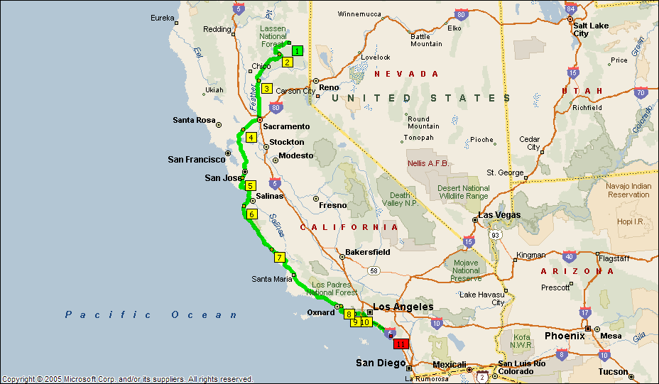
Friday's Route |
The first night was in Plymouth located in Gold Country near Sutter Creek. The selection of the route was a challenge. The more direct route would require riding through the San Joaquin Valley in the heat. The predicted temperatures near 100 did not sound inviting at all to me. Instead, I chose a little longer (but cooler) route. I headed north and west towards Malibu and then followed the coast north through Morro Bay, San Simeon, Big Sur and into Monterey. I followed PCH around Monterey Bay until I picked up Hwy 17 in Santa Cruz. I followed I-880 then I-680 to I-580 via Hwy 84 where I picked up the Bay Area traffic leaving town for the holiday weekend. I had to lane split all the way through Stockton until I was able to finally get on a nice country road: Hwy 88.
 |
 |
 |
| Campsite in Plymouth | Old Steam Engine | Commemorative Plaque |
| click on image for larger version | ||
I rolled into the Amador County Fairgrounds a little after 7 pm, just in time to check in and pitch my tent before I lost sunlight. After making dinner (tasty chicken and rice), I found a table and some light so that I could digest the route to our next evening's destination: Susanville (near Lassen National Forest). By the time I had digested the route and had a chance to meet and greet before I realized it was 11 pm and I hadn't yet taken my shower. Needless to say, it was midnight before my head hit the pillow.
Total for the day: 611 miles.
Saturday
It's only 300 miles, right? What's the hurry? Yet, most of the 100+ participants are out of the camp before 7:30. I don't get it. Me? I brew a batch of Starbuck's and enjoy the great morning. I call my wife, Nancy and my sister, Carol. I don't pull out of camp until a quarter after nine.
What a great route. As is always the case, I find roads I would have never found on my own. The only problem I had was finding the correct route out of Auburn which cost me about half an hour on top of the time I allocated for a leisurely lunch in Old Town Auburn. My favorite segment was the Quincy - La Porte Road which, amazingly, connects Quincy and La Porte. The road had a new surface and was really, really sweet.
 |
 |
| About this time of day Nancy would have said "O.K., I'm done with trees". | |
This was one of the
longest 350 mile days I can remember. There were some great roads; some of which
aren’t published on the state AAA map (the roads are too small and obscure). I
was one of the last ones pulling in (nearly
I picked up my packet for
the next days ride to find out that the route would take us to Yerington, Nevada
which is southeast of Carson City about 35 miles as the crow flies. Not only did
this route require desert riding, but it would mean I would spend all day Monday
riding Hwy 395 home. Neither prospect was appealing to me. I immediately planned
to see if I could find a campsite near
 |
|
Saturday's Route |
Total for the day: 345 miles.
Sunday
I went to bed earlier on
Saturday night (before
Not long after daylight, I'm on one of the best roads of the weekend: Hwy 70 which connects to Hwy 89 between Quincy and Greenville and runs southwest connecting to Hwy 99 just north of Oroville. The road not only is a pleasure to ride due to its gentle sweepers, but the scenery is fantastic. The highway is on one side of the North Fork of the Feather River while a railroad line is on the other. Along the way I'm entertained by several steel truss bridges allowing the railroad to follow the rugged canyon. This route is a true testiment to the WPA in that there are also about half a dozen mini hydro electric plants along the way. I promise myself to spend more time on this road sometime soon. Just not today.
Two hours after leaving
camp I put my foot down for the first time in Oroville for breakfast and my
first cup of coffee (that’s right; no Starbuck’s for two hours!). Two hours
later, I stopped for gas about half way between
I stopped for a cup of
coffee at Ragged Point and then continued south to my final gas stop in
I rolled into the driveway
at
Drat. It’s time to change the oil again. It’s been only 49 days!
|
|
|
Sunday's Route |
Total for the day: 792 miles.
Total Trip: 1,748 miles.